Sorrento Amalfi Walk With Us
Hiking in the Sorrento Peninsula and along the Amalfi Coast

<!-- Global site tag (gtag.js) - Google Analytics -->
<script async src="https://www.googletagmanager.com/gtag/js?id=UA-46324036-1"></script>
<script>
window.dataLayer = window.dataLayer || [];
function gtag(){dataLayer.push(arguments);}
gtag('js', new Date());
gtag('config', 'UA-46324036-1');
</script>
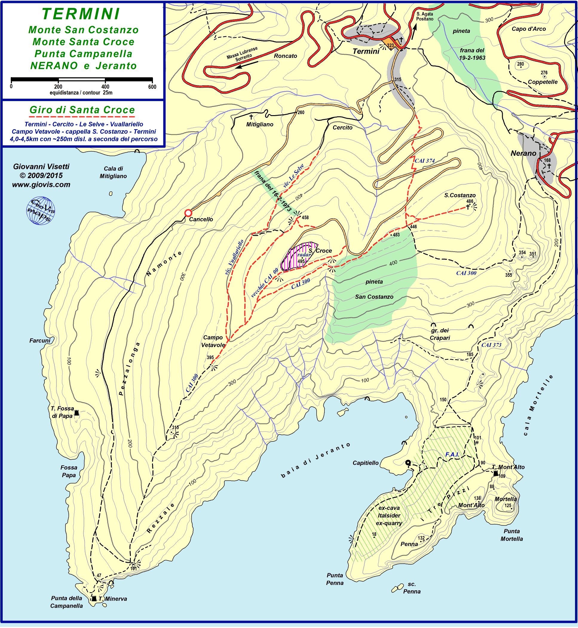
Santa Croce Loop


View from the chapel of San Costanzo
Fast becoming one of my favourites, this hike is an excellent alternative to the walk to Punta Campanella (Athena Trail). It will not take you to Punta Campanella being considerably higher up the hillside but the views more than compensate.
Starting from the village square in Termini, follow the signs to Punta Campanella. Walk down the road and turn right just before the bar/kiosk (always routed Punta Campanella). As you come to a very tight bend going steeply downhill, do NOT follow the "main" road, but go straight ahead towards the dead-end along what is Via Cercito. You will find that the lane passes between some houses. Keep on going until you have passed a large white house to your right and come to an intersection. Here keep straight on (ie do not go down to the right where there is a Private Property sign). A few metres further on, to the left of some wire fencing, the trail starts. Sometimes it is tricky to make out due to vegetation but it clears after a few metres.
The next stretch is straight forward and completely in the shade, taking you steadily, and at times steeply, up through the woods. Once past the rustic wooden rails (mainly fallen down!), you will come to some distinctive horizontal caves on your left (where the villagers sheltered from the bombardments during the war), followed by stone steps going up. These bring you out of the woods and into the open, providing sudden and magnificent views of the coastline and the island of Capri. Be careful of a couple of holes (partially covered) and once past them, follow the track uphill for a few metres before veering to the right and going straight on.
Departure Point - Termini village square
Type - circular
Distance and difficulty - 4 to 4.5 km. elevation approx.
250m. Easy or moderate depending which end route you take.
How to get there - SITA bus from Sorrento/S.Agata/Massa
Lubrense or by car. If by car, parking spaces are limited and
payable by pay and display.
Useful info - Water fountain in square. Bar and small food
shop. Excellent family-run restaurant Eughenes.
More info
https://www.giovistrailmaps.com/2-campanellajeranto
UPDATE 14/08/2022
The sign indicating Monte San Costanzo Via Cercito you can see in
the photo is no longer there. However just follow the road down
by the steps.
The path continues along the hillside, the amazing views accompanying you all the way. If you look up to your left, you can see the ancient dry stone wall terracing and a burnt down shed that once upon a time housed cows. Infact, the path you are now walking along was once used by the villagers to access the land they cultivated on these very same terraces. You will eventually come to an intersection with the official CAI300 trail (marked by a ceramic tile).At this point it is well worth following the CAI trail downhill for a couple of hundred metres to admire the views of the Bay of Jeranto from the rocky outcrop you can see below. Walk back to the ceramic tile and you can then decide how to complete the loop, including a trip up to the white chapel on top of Monte San Costanzo.
Option 1 - start ascending the CAI300 trail and take the left-hand fork which will take you along the path above the ruined shack you can see to your left and well below the "radar". This will eventually bring you to a rather ugly concrete railed belvedere. Admire the view down towards S.Maria Annunziata and then continue straight up the track and out onto the road, turning left. Follow the road as it turns to the right and brings you to the pinewood at the foot of Monte San Costanzo. Walk up the path to the chapel.
Option 2 - continue uphill along the CAI300 trail joining the old CAI00 trail at the ceramic tile which will lead you up to the edge of the fence passing to the right of the "radar" base. At the top this is very rough underfoot (loose stones) and definitely not for anyone suffering from vertigo as it is also very exposed. It is my least favourite of the three options in spite of the amazing views of Jeranto and the wild orchids in springtime. The path then descends to the road and from there you can take the trail beneath the pinewood up to the chapel.
Option 3 - start going uphill along the CAI300 but take the fork to the right (easily missed, although the signage has been refreshed). This is the most spectacular of the three options but again not for anyone suffering from vertigo! The path continues high above the Bay of Jeranto before coming into the pinewood. Again fantastic views but watch your footing since the path is narrow and the drop considerable.
For all three options, once in the pinewood, follow the trail in the direction of Monte San Costanzo until you reach the steps leading up to the chapel. At the start of the steps you will see a board with a list of names. In 2001 the local authorities planted a tree at the side of the path for each baby born locally that year and these are their names. From the chapel, there are 360 degree views. In May, the villagers carry the statue of their saint all the way from the church in Termini up to the chapel , bringing it back down in July. The occasion is marked by a lot of noisy fireworks and the local brass band.
Walk back down from the chapel following the main path down to the road. Then either follow the road back to Termini (easy), or take the shorter but steeper and rougher cut-throughs.